A large earthquake off the coast of Alaska last night set off tsunami warnings (that were later cancelled) up and down the West Coast of the United States. Residents on Alameda, the island in the San Francisco Bay where I live, were all curious why we never got any warning waking us out of our beds. The answer was that there never was enough of a threat but I was curious enough to do a little research and found that others had asked in the past so I’d thought I’d summarize and post what I found for future reference.
As you can see in the simulation of a 16 foot tsunami in the video above, most of the energy of the of the wave is absorbed by the Pacific coastline and dissipates as it tries to squeeze through the Golden Gate. A more detailed video can be found here.
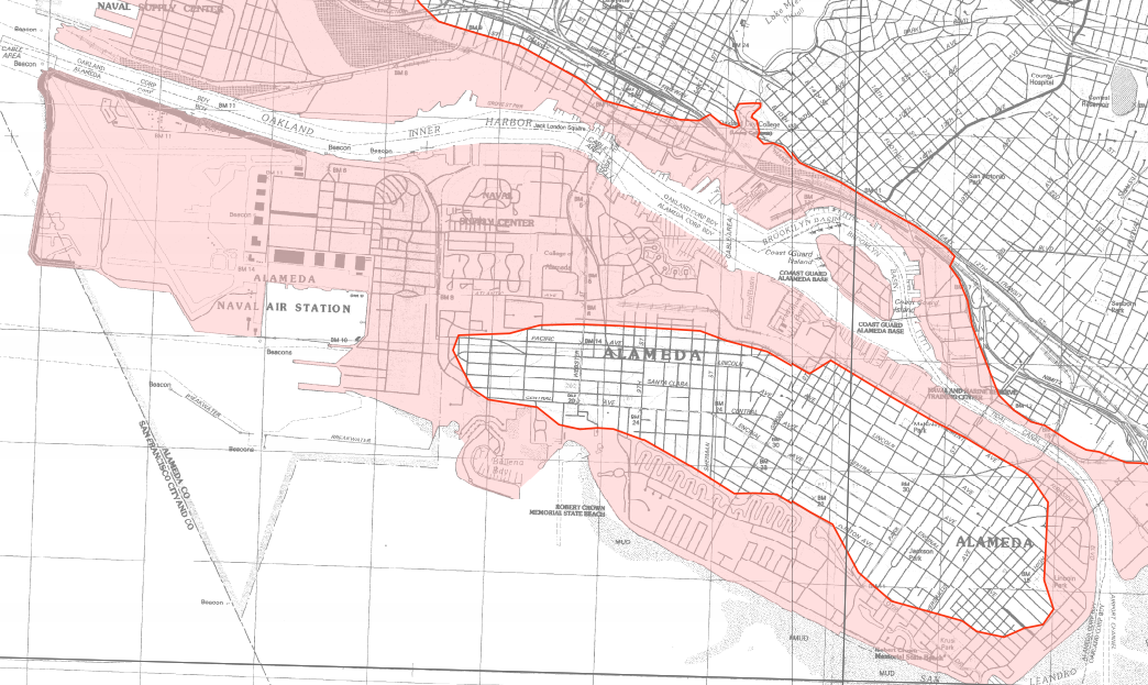
By the time the wave reaches Alameda, most of the energy is gone but there is still some danger from flooding. California has posted a full set of Tsunami Inundation Maps that are a useful resource. I pulled together the relevant section for Alameda.

Luckily, there’s a lengthy study published in 2016 on tsunami evacuations that used Alameda as case study. The study looks at three types of tsunami events with the most severe being one in which the waters would cover the island as in the illustration above. While the advance does cover much of the island, the study concludes,
One mitigating factor is that potential sources associated with a Zone 3 evacuation are likely distant earthquakes only and expected tsunami arrival times of 4 h or more should provide sufficient time to implement a successful evacuation before wave arrival.
This has to do with the geologic faults that are off the coast of California. Back again to the Bay Curious post linked at the top.
Tsunamis are caused when one tectonic plate slides underneath another — a process called subduction. This slow movement is happening all the time, but sometimes a plate will get stuck and pressure starts to build. When it finally lets go, there’s an underwater earthquake that can move the seafloor up and down, sending a wave to the surface of the ocean.
But the San Andreas Fault is different. It’s called a slip-strike fault because the two plates slide past each other horizontally. Of course, whenever plates move, the ground shakes. But here, there is no subduction and little displaced ocean.
Meaning no killer tsunamis. Even San Francisco’s infamous 1906 earthquake generated only a 4-inch wave at the Presidio gauge station.
So there you have it. If you get a tsunami warning that is something to worry about, you’ll have a couple of hours to make your way to Park Street or the Alameda Theatre parking structure where you can get a view and watch the wave come in.
References:
Intra-community implications of implementing multiple tsunami-evacuation zones in Alameda, California
City of Alameda Local Hazard Mitigation Plan (pdf)
What Would Really Happen if a Tsunami Hit the Bay Area?
UPDATE:
Wired put out a story on March 7th about a new study that used LIDAR to conclude that some areas of the SF Bay are sinking. Alameda main island seems ok but areas of Harbor Bay are in danger.
Leave a comment