Oh my God – this is so bad it’s funny. Dave Cassel of 10 Zen Monkeys deconstructs a radio spot on the GPS-enabled Helio that features a jingle refrain that’s going to stick with me a long time. I don’t think this was what Google was thinking when they set out to “organize the world’s information.”
Tag: maps
-
flickr images in space and time
I was going to hold off on the Yay! Yay! Yahoo! posts for awhile after such a long string of them but then flickr took it’s wraps off it’s maps integration and I couldn’t resist. If you haven’t had a chance to play around with this, check it out. From your flickr account you can now Organize photos on a new Map tab. True to form, it’s all drag and drop and you can also set permissions because everything you drag onto the map will be thrown into the general collection of photos that everyone else drags onto the table. Look at the image above and to the right – this feature was launched only this afternoon and there are already over 15,000 (as of 11pm tonight) images polka-dotting the San Francisco peninsula!
Upcoming.org also adding flickr integration today with a handy-dandy tag generator for each upcoming event (they also pushed out a number of other changes which spiff up the site quite nicely). How many times have you been to one of those “well-documented” events where it seems like the people are more interested in moblogging each other than actually speaking (maybe this is just a Bay Area thing). At some point, someone gets the bright idea that it would be great to have everyone tag their collective photos so they can be pulled together under one URL. The recent TechCrunch/August Capital bash generated a ton of photos that were all looped under the techcrunch7 tag which was whispered from photographer to photographer as the evening went on. Now Upcoming resolves the doubt and debate and generates a tag for you right on the calendar entry for the event later crawling flickr to look for that tag to integrate thumbnails of your photos right onto the event page (see image above).
In one brilliant stroke we have a community of images in space (maps) and time (upcoming). I think it’s safe to say that we are living in one of the best documented ages ever. Archeologists of the future are going to have more than enough material to work with but I wonder what they’ll think about this sudden explosion of images in the early 2000’s – what caused this sudden impulse to re-interpret the world around us and categorize and share everything?
UPDATE: after only 24 hours Stewart writes that over 1.2 million photos have been geo-tagged. Never under-estimate the human desire to put things in their place!
-
TechCrunch on Mapping Services – Yahoo “by far the best”
Ok, a little shameless high-fiving all around for the folks behind Yahoo Maps. Here’s Frank Gruber on TechCrunch after comparing Ask, Google, Mapquest, Windows Live, and Yahoo:
Its fast Flash interface, multipoint directions, live traffic information, and easy send-to-mobile feature make it the hands down winner. It also features the most robust API options.
Check us out at maps.yahoo.com/beta
-
Realtime Flight Tracking
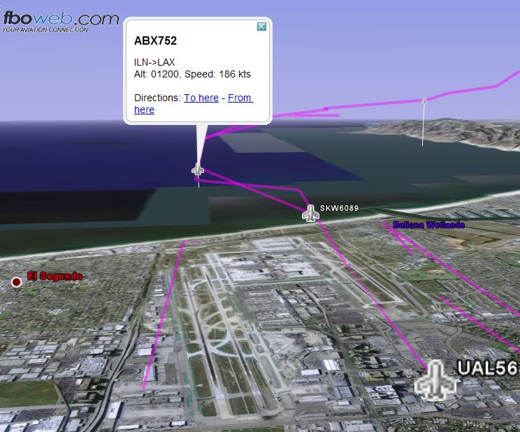
Hey it’s Friday so here’s a little gee whiz technology to play with over the weekend. Aeroseek has added a button to their realtime tracking service that downloads an overlay file that you can view on Google Earth if you have it installed. It updates every minute so you can watch grandma march across the Wyoming on her way to San Francisco.
-
Containers as Commerce Packets

The first newspapers came about back in the 1700’s to fulfill a need for importers and others with an interest in trade with the New World to keep track of the shipping schedules and see who was due into port that day. Tucked away in the business section of some papers you still see announcements of the day’s arrivals but it’s just a vestige of what I’m sure it used to be and I’m sure no one subscribes for this sole purpose.
Today, Jason Kottke points to Shiptracker which uses voluntary weather reports from ships around the world to track the location of ships in realtime. Imagine each of these dots pilied high with containers and then you get an idea of what kind of logistical problem faces an agency that wants to examine everything before clearing it for commerce. According to one document I found, US Customs cleared 5.7 million containers in 2001 but only checked the contents of 2% of them. There’s also later news reporting a much higher rate to the contrary.
In the old days, sending CDs via FedEx used to offer better throughput for businesses that needed to send large files back and forth to each other. I wonder what the true throughput of today’s shipping network is and how it’s changed since September 11th?
-
Google Earth, the ultimate time sink
So I thought I’d spend some time catching up on some reading tonight but nooooo. . . Google released a new service called Google Earth and the rest of my evening was blown playing around with the program and then making a screencast just to see if I could.
I punched in a bunch of addresses of places that I lived and created a little fly-by tour complete with narration using Windows Media Encoder and you can see the fruits of my labor in the video below.
-
Real Estate as an API
This is a great case when two APIs get hooked up to make something greater than what each service could offer on its own. Paul Rademach, a tech lead for animation tools at Dreamworks, has connected Google Maps to Craigslist to present a visual UI for real estate listings. You can set your location and price parameters and get a map that you can zoom in on and scroll with pinmarks for every “hit.”
A yellow pin indicates that photos are associated with the listing and clicking on the pin will bring up the information from Craigslist as shown in the image on the left.
I dreamed something like this would be possible with other layers being added in as needed like those old Mylar overlays you would see in atlases or anatomy textbooks. I can already think of two overlays that I’d like to see if I were a homebuyer. Comparables and School Districts. Once geo-locater enabled web services are exposed for this data, it would be fairly trivial. I think much harder is getting this data.
-
Maps? Cool. Satellite Overlay? Wicked!
So those of us on the bleeding edge have all seen Google Maps and have commented upon the clever use of XML datasets to create a seamless browsing experience. Just when you thought it couldn’t get any better, BLAM! Google took the wraps of an overlay which provides a satellite image of any map you bring up.
This includes driving directions so you can zoom in and “fly along” your commute to work. Nice touch is that the speech bubbles that are used to annotate the addresses generate a shadow on the satellite image.
-

Wonderful Web World
As I look for the cross-section of schools and interesting-but-reasonably-priced places to exist (does such a thing exist in the Bay Area?) I found myself wanting for a school district map overlayed on top of a map showing available placed to live. I’ve found pieces of the puzzle:
SF School District Map
greatschools.org
SF Zip Code MapIf only I could overlay the available listings which you can pull up in realtor.com or apartments.com using a zip code then I would be set.
In the course of looking for a tool that could tie zip codes to neighborhoods to school districts, I ran across this wonderful site by MIT Media Lab doctoral candidate, Ben Fry. His interactive Zip Code tool is one of the coolest things I’ve seen in awhile.
UPDATE: Now 10 years later Google Maps has started to layer this information as an extension of their Google Maps service. Check out the mash-up of greatschools.org ratings and Google Maps.
Check out more mashups at the Google Maps Gallery.